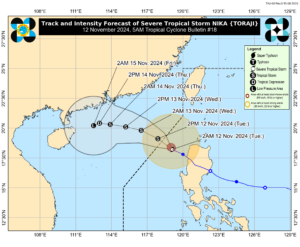
Severe Tropical Storm Nika continues to weaken and is anticipated to exit the Philippine Area of Responsibility (PAR) by Tuesday afternoon, Philippine Atmospheric, Geophysical, and Astronomical Services Administration (PAGASA) said.
After making landfall over Dilasag, Aurora, and sweeping across Northern Luzon on Monday, Tropical Storm Nika weakened from a typhoon to a severe tropical storm by Monday evening.
Nika now has a maximum sustained winds of 95 km/h near the center, with gusts of up to 115 km/h, according to a weather advisory released by PAGASA on Tuesday at 11:00am.
The storm located 225 km West Northwest of Laoag City, Ilocos Norte (18.8 °N, 118.5 °E) and is moving Northwestward at a speed of 10 km/h.
PAGASA reported that if Nika maintains its current speed, it is expected to exit the PAR by Tuesday afternoon. However, its rainbands will still directly impact parts of Luzon, bringing heavy rains and strong winds to affected areas.
Wind Signal No. 1 remains in effect for areas including the northern part of Ilocos Norte (Sarrat, Piddig, Bangui, Vintar, Burgos, Pagudpud, Bacarra, Adams, Pasuquin, Carasi, San Nicolas, Dumalneg, Laoag City), the northern portion of Apayao (Luna, Calanasan), the northwestern portion of Cagayan (Abulug, Pamplona, Sanchez-Mira, Santa Praxedes, Claveria), and the northwestern portion of the Babuyan Islands (Islands of Calayan, Dalupiri, and Fuga).
PAGASA warns that winds of 39-61 km/h are expected in these areas within the next 36 hours. Damage to medium to high-risk structures is possible.
Moderate to heavy rainfall, ranging from 50 to 100 mm, is also anticipated over these areas within the next 24 hours. PAGASA cautions that this could lead to localized flooding in low-lying and urbanized zones, as well as potential landslides in highly susceptible areas. – Edg Adrian A. Eva

